List of businesses
Geodézie - ZPK Hořice

Geodézie - ZPK Hořice

  • Surveyors
Haberská 156, Hořice
Closed · opening today at 8:00
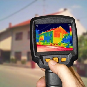
We perform complex geodetic work. Geometric plans, surveying of buildings and delineation of boundaries. We produce map documents for designers. Digital terrain models. Measurement of buildings by 3D scanner. Engineering surveying. Thermal imaging of buildings.
Geodeti-ADM Geodetické práce

Geodeti-ADM Geodetické práce

  • Surveyors
Libňatov 85
We offer geodetic services in the field of cadastre and engineering geodesy - semi-topographic and altimetric surveying for the project, Building alignment, GAD (geodetic updating documentation for DTM), Geometric plans, Boundary delineation, Building passport, Actual building design, Calculations of cubic capacity.
Trigorn

Trigorn

  • Surveyors
Staré Buky, Prostřední Staré Buky 165
We offer all surveying work, in cadastral and engineering surveying, geometric plans, land surveying, utility surveying, laser scanning, elevation and position surveying. We will help you resolve inconsistencies found during cadastral revision.
Jan Vaněk - Geodetické práce

Jan Vaněk - Geodetické práce

  • Surveyors
Rudník 82
Closed · opening today at 7:00
We offer geodetic work, creation of geometric plans and map documents, surveying of utilities or buildings and delineation of land boundaries. We provide position and elevation surveys. We also provide the preparation of purchase contracts for the geometric plans made by us and entry into the Land Registry.
Josef Štěp

Josef Štěp

  • Surveyors
Rudník, Arnultovice 12
Offering surveying work. Creation of geometric plans and map documents, surveying of utilities and buildings and delineation of property boundaries. We can also offer the preparation of purchase contracts for the geometric plans prepared by us and ensuring the entry into the Land Registry.
Ing. Jiří Fiedler

Ing. Jiří Fiedler

  • Surveyors
Jižní 870/2, Hradec Králové, Slezské Předměstí
Closed · opening today at 8:00
Engineering surveying, mapping, geodetic work, land registry surveying, geometric plans. We provide all surveying, delineation of building objects, property boundaries. We offer aerial photography, photogrammetric evaluation of the territory.
MC Dron

MC Dron

  • Aerial photography and videography
Tetín 53
I provide drone flying services. I specialize in high-altitude inspections of objects, buildings and terrain, both visual and thermal, using a drone with a thermal camera. I also offer 2D/3D mapping, aerial photography and video, creation of 3D models using drones. I use modern technologies.

We display 7 results found

with tag Fotogrammetrie in Hradec Králové Region.