We offer geometric plans, property boundary marking, plotting and documentation of the actual condition of buildings (monolithic and steel structures) and utilities. We provide 2D and 3D mapping documents, building surveying, mining surveyor activities. We are equipped with robotized total stations.
The activities of our geodetic company include mainly engineering geodesy, mapping, geographic information systems and cadastre. Special geodetic works include geotechnical monitoring and presentation of its results in Cubula.
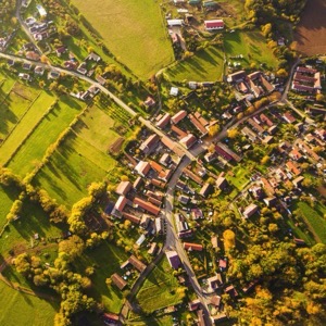
We are general building contractors We are surveyors and we survey in 2D, 3D and drones We are locksmiths We are electricians. We offer modern surveying services. Our methods include laser scanning and aerial photogrammetry for accurate measurements. We will build your dream home from design to completion.
Providing services in vectorization and creation of 3D models or conversion of paper documentation into digital form. Supply of large format printers. We create 3D interactive landscape visualizations, mine survey documentation, design mineral extraction and mitigation.
We offer surveying services. We are involved in creating surveying documentation, surveying utilities, delineating property boundaries or geometric plans. We also focus on the creation of large-scale special-purpose and digital maps. We are ISO 9001 certified.
Offering engineering surveying services and land registry work. We produce map documents, digital maps, technical maps or expert reports. We provide structural and technical documentation of buildings and surveying of floor and rental areas. We deal with the processing and evaluation of surveying images.
We offer a complex of services in the field of geodesy, laser scanning, 3D documentation, photogrammetry, construction machinery control and data preparation, aerial work by drones.
We specialize in aerial work with drones: thermography, photogrammetry, video and photo production. Professional services for your projects with centimeter accuracy. Damage mapping, animal search, hunt audit, inspections (roofs, fve), 3d models, promotional photo/video.
We deal with civil engineering documentation and engineering surveying. We provide development of surveying software, preparation of geometric plans and surveying of buildings. We provide consultancy in the field of land registry.
We carry out surveying work in construction and cadastre, geometric plans, property boundary marking, building demarcation, documentation of actual construction, purpose maps and project documents. Development and real estate activities. We work throughout the whole territory of the Czech Republic.
We offer 3D scanning, VR application and game development, virtual reality. We provide 3D scanning services (objects, buildings, environments, monuments, people). We develop applications and games for virtual reality.
We specialize in solving technologically highly demanding projects and providing works and services in the fields of engineering geodesy, digital photogrammetry. We offer geodetic work for the land registry, delineation of land boundaries, preparation of geometric plans.
We are a purely Czech company that has been operating on the market since 1991. During that time we have developed into one of the largest providers of geomatics services in the Czech Republic. We provide comprehensive services in the areas of engineering geodesy, geographic information systems, 3D data and BIM.